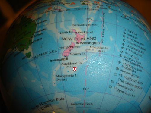
Some Captured History of Glanamman and GarnantOther Areas: Down UnderSo what is on the opposite side of the world from Cwmamman? For the sake of simplicity, we shall take the centre of Cwmamman as being at the junction of Ceidrim Road and Cwmamman Road, on the border of Glanamman and Garnant. The map coordinates for this location are (rounded to) 51.8° North and 3.9° West. The height above sea level at this location is approximately 348 feet. There is an old misconception that Australia is "Down Under" and directly underneath the British Isles. In fact, at map coordinates 51.8° South and 176.2° East, we find the New Zealand Plateau, which lies beneath the Pacific Ocean! The nearest land is the Antipodes Islands which lie approximately 195 miles to the North East, while New Zealand lies approximately 465 miles to the North North West.
X marks the approximate opposite end of the earth to Cwmamman The Earth isn't a perfect sphere, the circumference from pole to pole being slightly less than the circumference around the equator, though the difference is only about 42 miles; less than 0.17%. A person leaving Cwmamman to circumnavigate the Earth would find the distance to the opposite point on the Earth to be approximately 12,450 miles away. On the other hand, if it was possible to dig all the way through the earths core and straight out at the other end, the distance would be much shorter at approximately 7,900 miles. This information is of course accurate at the year 2010, but the earth is a dynamic planet, being the only planet in our solar system with tectonic movement (where the land masses move, sometimes causing earthquakes and volcanos). This means that Cwmamman is moving, as is the rest of the world. Two hundred and fifty million years ago, the world consisted of only one super sized continent known as Pangea, until the earths tectonic movements forced the continent apart in different directions to form the world as it is today. It is estimated that in 250 million years time, the continents will have crashed together again to form another Pangea. It is interesting to note that there is a district named Garnant in Queensland, Australia. It is located at approximate map coordinates 23° South 150° East in the county of Fitzroyshire, Capricornia, postcode 4702. The district is situated approximately 21 miles North West of the town of Rockhampton and is under the jurisdiction of Rockhampton Regional Council. *The August 24th 1950 edition of the Central Queensland Herald ran an article on Central Queensland place names. It explained that Garnant QLD was "so named by pioneer settler H. Jones after a copper and tin smelting district in Wales". The present school at Garnant QLD opened in 1930. Garnant QLD is a rural area consisting of only a few farms which are dispersed throughout the locality. The landscape is relatively flat and sits approximately 105 feet above sea level on average. Garnant, Australia is ten hours ahead of our Grenwich Mean Time, being in the AEST zone (Australian Eastern Standard Time). There are ten roads in Garnant QLD, namely Bishop Road, Blanche Road, Calmorin Road, Chippendale Road, Evans Road, Garnant Road, Ridgelands Road, Roffey Road, Salmon Road and South Yaamba Road. To draw some further comparisons, our nearest railway station at Tirydail, Ammanford is approximately four miles away, whilst the nearest railway station to Garnant QLD is at Merimal, a distance of around 17 miles to the NNW. The nearest airport to Garnant QLD lies near Rockhampton and is under 20 miles distant, whilst we are over 41 miles from Cardiff Wales Airport. *Thanks to Rockhampton Regional Library for their contribution to this page.
|